The Logging Road Cyclist was in a somber mood, and dearly needed a good ride to set up his spirits. Saturday was absorbed by attending a memorial service for another passed kayaker. This one, B, hailed from the earliest days of TLRC’s paddling career. Along with his older brother C, B was a fixture in the early ’70’s whitewater scene in the Bay Area, when TLRC barged into it at eighteen years old. B, C and TLRC were about the same age, but the former were both already very accomplished paddlers. They provided inspiration for the flailing TLRC; in return he provided them with much amusement as he variously missed rolls, swam, broke boats, bent paddles, etc etc, the usual antics of a hyper-enthusiastic, under-skilled novice paddler. B went on to Olympic-level flat water racing and a stellar academic career, C to slalom and ever more hair-raising whitewater on much of which TLRC joined him along with fellow teenagers R and Heathcote. While TLRC only knew B during the ’70’s and drifted away later, B formed a part of the pattern in the fabric of TLRC’s life at an important time: for TLRC whitewater was formative and sustaining for his entire adult life, and B was there at the start of it.
Aging is tough. As Philip Caputo put it in one of his novels, 50 is the age when a man’s friends start to die. At nearly 60, TLRC finds this true, and it is especially unnerving when the friends are younger and arguably as fit or fitter than he. B was 57, still an athlete, a student of heart physiology: he did all the right things. Heathcote, the friend of TLRC’s life, went 5 years ago in his early 50’s from a fast, hot cancer that was never figured out. Thus TLRC, R and C are left, and at the goodbyes to their friends and brothers they find themselves together in the midst of grief, wondering why, sharing the past, sheltering with each other in the now.
Thus the need to get out. Coupled with the flail along the North Siletz before the big snow and rain shut down the backcountry rides for a few weeks, TLRC wanted to actually accomplish something.
Fortunately the steadfast D was available. He too needed to get out. A lobbyist for fish, D had been doing a lot of fish-saving lately, and while much of what D does mystifies TLRC, it is apparently fairly sedentary. D is a good companion in times like these. He empathizes as much as is needed, but not more, and refuses, in an amazingly diplomatic way, to allow TLRC to wander down into the dark cul-de-sacs of the TLRC mind. In short, he gives TLRC exactly what it is that TLRC needs at these particular times. Plus, D infused the day with an undeniable spiritual energy. While TLRC was down in Eugene grieving, D was up on the Necanium catching his first wild steelhead on spey gear. The fullest meaning of this may escape TLRC and other civilians, but since D carried what looked suspiciously like a halo all day, TLRC figured it was a Siginificant Life Event, as it were. At any rate, it cheered things up.
Check this out:

The red line is the first 13 or so miles of the Luckiamute River, which flows from high up on Bald Mountain, down through Kings Valley and Pedee to the Willamette, 50 or so river miles away. TLRC had first sort of noticed this a few years back, but with all the recent riding activity in the Valsetz Triangle, he went back to his maps to see if it was really true that the Luckiamute actually spiraled down off Bald Mountain like this. It is impossible that this is a unique sort of watershed, but TLRC can’t recall seeing one himself. It brought to mind certain other spirals:


Unique or not, it certainly beckoned, both to D and TLRC, and they were drawn to it, that and the fact that they had both stumbled around on the east side of Bald Mountain a year or so ago and were looking for another opportunity to go back and connect some dots, fill in some blanks.
So Sunday’s project was fixed. From the Hoskins-Valsetz road, up the spiral along the upper Luckiamute, around the east side of Bald to the Summit, back around the west side and then connect north to the Valsetz Road. A swoop down the South Siletz (site of recent spawning studies by D and dedicated Bluebacks) to Valsetz and then back over to the Luckiamute. This ride would allow a lot of connections to be made between the various watersheds recently explored by our team.
The upper Luckiamute is a pretty stream, and maybe kayakable, just.

Luckiamute at the second bridge. Note handmade bicycle in British Racing Green.

Upper Luckiamute

View W down the Luckiamute. Fanno Peak in the distance.

Bald Mtn from the North, looking across the Luckiamute.

Pond at the origin of the spiral.
Once past the headwaters, there are spectacular views from the east around to the west, like this one into the Valsetz Triangle.

Valsetz Triangle from Bald Mtn.
The largest clearcut in the distance on the right side of the photo lies above Valsetz Lake and the exit of the SF Siletz. The indistinct low ridge in front of it is the Siletz-Luckiamute divide. Note the hummocky, dissected terrain that forms the upper part of the Luckiamute watershed. A point of interest: As if the Siletz basin hasn’t been insulted enough already, there are plans afoot to rebuild the Valsetz dam to for water storage purposes. Apparently Polk County intends to sell water to thirsty coastal towns and use some for itself. Avid Siletz steelheaders are not pleased….
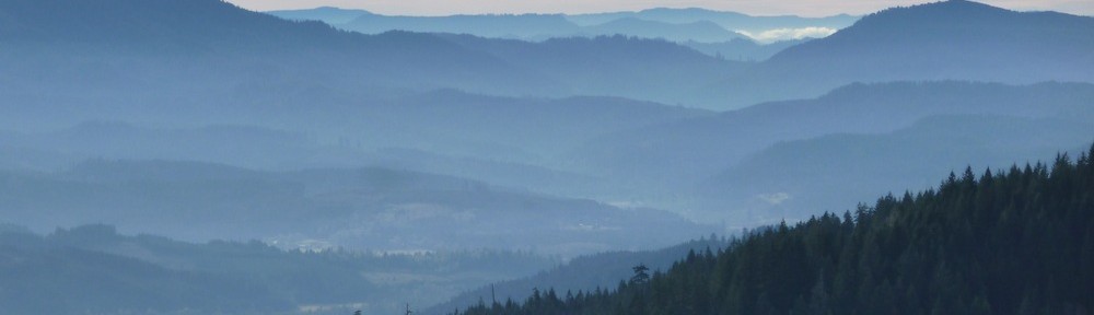
Finally, from the summit of Bald Mtn are spectacular views of the Willamette Valley and Cascades that the cheap camera and poor skills of TLRC cannot do justice to:

View E from summit of Bald Mtn.
The route around the west side of Bald is straightforward, as is the connection north to the Valsetz Road, which is a fun slide down to the lake. An easy climb leads back to the start of the ride.
This is a moderate (26 miles, 3600′) ride that takes in a lot of country, has some beautiful stretches of forest (on BLM lands), great views and connects a lot of the watershed topology of the area. Highly recommended. The ride is here: ignore the last few miles with sustained speeds in excess of 20mph. The ever-helpful D loaded up TLRC’s bike before the GPS got turned off.


