Local Big Views

Someone recently asked: “TLRC, would you mind displaying a recent example of your widely known and highly praised deductive powers?” Of course. The Logging Road Cyclist is happy to indulge.

Why just the other day, TLRC and his buddy Gnat did a ride out to Big Saddle, where they had some Big Views. These, he did not note at the time,  but will now, are generally the result of the big private logging companies turning conifer forests into views through the obvious expedient. Well, he deduced, since OSU Forestry is the source of academic insight into forest management and probably taught the companies a thing or two, and since OSU Forestry owns forests near home, then pretty likely some conifer forests had been turned into views that TLRC could go see without the drive out to Valsetz.

He decided to visit Forest Peak, a place he had been many times before, but not much lately. Given the general rate of view-making in the Coast Range in recent years, and on OSU property in particular, perhaps, he reasoned, there’d be some new views to be had. A test of his “deductive powers” lay to hand.

It was a beautiful winter day, sunny and warm. Dropping from the Nettleton Loop down to Soap Cr affords some pretty nice scenes.

A View fights back against the upstart Conifers

The ride has a couple of offensive stretches of pavement, up to and along Tampico Rd going out, and from Soap Cr back to Sulfur Springs coming back. From Tampico Rd to the north lies the impressive basalt wall of the dump, capped by the little geodesic dome (look close).

TLRC once was told (probably apocryphally) that the dome was the local radar for the BOMARC antiaircraft missile installation that was nearly completed and abandoned at Adair Village. Certainly there is a lot of concrete left over at Adair from it. BOMARC was an early cruise missile that had about a 400 mile range and could go Mach 2.5. It was 45 feet long, 18 feet wide and hunkered in bunkers and tilted up to launch vertically. It carried either conventional or nuclear warheads. Think about that the next time a younger person talks about growing up in the shadow of Apocalypse. TLRC grew up with getting-under-your-school-desk-to-mitigate-the-nuclear-blast drills in a time when setting off an atomic airburst near the coast off Portland or Seattle to get a bomber seemed like a good idea compared to the alternative.  TLRC waits for it: OK Boomer.

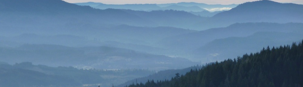
The climb up from Tampico to Forest Peak is about 4 miles and pretty stiff. At about two miles, is the reward:

A not-quite-perfectly-constructed-View, but pretty darn good

TLRC has been coming up here for years now, and was startled at how much light there can be.

On the other hand, the elves have lapsed at the top, and the View at the summit of Forest Peak gets worse every year, a good excuse not to do the final excruciating couple of hundred yards to the top.

Summit of Forest Peak


Big Saddle; Big Surprise

The Logging Road Cyclist is, generally and by most accounts, an enthusiast. The enthusiasms vary, to be sure, and sometimes follow one another in rapid and bewildering succession. But (dread word), he has become a bit jaded when it comes to digging out new rides. A, je ne sais quois, comment on dit sort of ennui has settled upon him. Fortunately his riding buddy Gnat has picked up the slack and has been proposing new routes with head-spinning speed.

This one was a loop up and over the steep ridge bounding Valsetz Lake on the west. A moderate ride as they did it at 15 miles and under a couple thousand of climbing. Indeed, this ridge, comprised of a hard diorite that props up the complementary features Big Tip and Big Saddle (!) also has the prominent gap at its northern end that held the dam that made the lake they called Valsetz (after the Valley and Siletz railroad). The big surprise of this ride was all the views.

This ridge lies below all the major features that ring Valsetz Lake, but is high enough to give a clear view of the lowlands and the surrounding peaks and ridges. TLRC has visited most of them at one time or another, but their height and positions make everything seem rather distant. Big Tip-Saddle ridge, with its lower elevation, gives a closer, more uniform view of what all is going on around Valsetz. Loge seating, as it were, for a local geography and (don’t worry, TLRC will leave it out this time) geology.

Here’s an area map so the reader can get the picture.


TLRC and Gnat started just down from the old dam site, and coasted a bit to the turnoff up the ridge. Gaining the first height, they had a great view smack down the main Siletz River. This is still way up above the whitewater run, rather in the area around the mysterious Falls.

Looking south down the Siletz canyon.

As they climbed higher and higher up the west side of the ridge, the views towards Stott Mtn and Sugarloaf got better and better. Swinging around from Stott, the watershed of the N Siltetz opened up, giving a view straight into the surprisingly sharp canyon of lower Warnicke Cr. and a sideways look at Boulder Cr. over a shoulder of Sugarloaf. The dusting of snow on the high country mitigated the otherwise depressing severity of both old and very recent, massive cuts.

Sugarloaf (center). Warnicke and Boulder Crs are to the left. Valsetz dam site lies directly below Sugarloaf

After not too hard of a ride, the pair attained Big Saddle. TLRC was hot for Big Tip, and sprinted off. The correct turn was uphill, and likely that and inexcusably bad map reading caused him to lead the happily lead-astray Gnat off on a goose chase where Gnat could pose his bike before an ocean view. They also had a very good look in profile at Big Tip. Truly protuberant, that would have been a cruel endeavor to mount, and they were just as happy to deflate their expectations and head on down.

On the way down, the clarity of the relation between the Oregon Coast Range Intrusive suite and local geography, and the fact that here, it is dioritic rather than the usual gabbroic stuff (leucocratic!) broke TLRC’s usual iron will, and he held forth to poor befuddled Gnat.

TLRC explains to Gnat exactly the situation in excruciating detail

On a simpler aesthetic note, the Valley fog spilling through the Luckiamute gap between Bald and Little Grass Mtns and over Cougar Ridge was just pretty.


Fourth of July Creek

Last week, The Logging Road Cyclist was poking around the internet looking for something or other about rides around the area and he stumbled upon this webpage. Seems like Mr. Bingelli too has gotten fascinated by rides in the Valsetz Triangle, that region bounded by the Laurel Mountain Massif-Bald Mountain highlands on the north, and the Little Grass Mountain-Green Ridge complex on the south. The Luckiamute River, drains it to the west and the South Fork Siletz to the east. If you stay off the highlands, its a good place to find moderate rides. TLRC recently found a fascinating paper on the geology of this region ( Baldwin, 1964) and got fired up to knowledgeably nose around out here again.

A few years ago, he had done a nice loop, riding up Rock Cr., down Sunshine Cr. and the Siletz, passing Fourth of July Cr on the way. He liked the name, and given all this recent interest, and a desire to close another Triangle loop, he and Gnat headed out on a truly dismal late February day to check it out.

TLRC gets ready to roll

The loop is about 18 miles and 900 feet or so of climb.


The ride started with the climb over the Luckiamute-Siletz divide, passing the turnoff to Chandler Pass. They rode in steady, heavy rain, marveling at the massive new clearcuts high on the east flank of Chandler Mtn. The ride is a combination of pleasant and interesting mixed second growth with astounding clearcuts where the old stumps of the first-growth stand out of the slash like rotted teeth.

It’s pretty easy to find the way. After crossing the divide and riding down Rock Cr a ways, one arrives at a five-way road nexus. Next take the one-two-third turn up Fourth of July Cr. From the top of the climb out of that creek, there are nice views back down the valley,

and east over to Chandler Peak

TLRC ponders whence he came

Chandler Peak

After the initial soaking rain, TLRC and Gnat had a bit of hail and a bit of wet snow before it got kind of sunny in a soggy sort of way. They basked a bit at the junction east of Valsetz, put on their spare sets of dry gloves and pedaled back to the car. TLRC wore his rain jacket all day, a rarity.

One reason TLRC likes riding out here is he gets to see his little black piggies. There were none on the way in, but going home there they were, and one came out to greet TLRC.

Narcoleptic piggy