The Logging Road Cyclist, the Curmudgeon of the Coast Range, had begun to feel just a bit jaded. He was redoing his old classic rides for the fourth or sixth time, and was feeling the lack of a partner who might infuse some new ideas for future forays. As luck would would have it, TLRC supped last Thanksgiving with a logger who REALLY knows the Range, and this guy showed TLRC a picture of this big waterfall nearby his recent worksite. “Warnicke Falls,” he said, “two hundred feet high”. A true lover of the Caost Range, this man had actually scrambled to near the base of the Falls (no mean feat) and gotten some clear and closeup pictures. A stunning sight. Having no maps to hand, and a balky phone, TLRC took a vague idea of The Falls whereabouts home and soon found it was near some familiar ground. Warnicke Cr., sponsor of the Falls, is a tributary of that old friend, the NF Siletz, next tributary up from Boulder Cr. (of Boulder Pass), and it debouches into the NF Siletz up by the Valley of the Giants, another known point.
Access was a whole ‘nuther thang. While there is a road that reaches part way up Warnicke, it falls short. No road, it seems gets to the Falls from the Siletz side. Short of some almost unimaginable intrigue from the West, the best ways in looked to be straight south from Grande Ronde on HWY 18, or via Boulder Pass at the head of Mill Cr.
The former seemed both shorter, and to contain some very interesting geology. Off went TLRC on a cold and foggy morning that he was sure would turn sunny once the heights were reached.
The ride follows BLM 6-8-13 8 miles or so to the top of a steep ridge, but the first few miles are along the scenic and very whitewatery Rock Cr. Were TLRC a younger man with two (2) functioning shoulders, he’d head back there immediately to run it.

View downstream from the first bridge over Rock Cr. That’s a 10 foot drop.
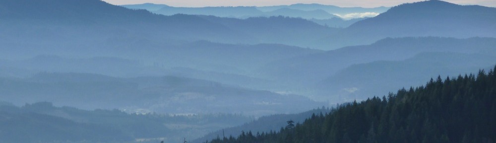
As the ridge crest nears, the road gets steep, and good views along this impressive scarp and off to the North are had:

View E towards Condenser Peak from the 6-8-13

Looking N down Rock Cr. and over Grande Ronde from the 6-8-13
In spite of this being a BLM-numbered road, this is emphatically private timber land, and just past the top of the ridge as one passes into the Warnicke basin, the gate is locked, but has a warm welcome for LRC’s:

TLRC had two goals. First he wanted to get downstream on the north side of the Creek in hopes of some views back towards the Falls. He got his wish, through the trees.


These shots, from about 1/2 mile away show how impressive these Falls are. Having taken this in, TLRC headed back to the head of the Falls. Not only did he want to look off of them, he was curious about the type of rock that could support something this impressive. So far, all that was visible in the local quarries and road cuts was the soft layers of the Tyee sand and siltstone, not the stuff of a big Falls.
The new clearcut at the top of the Falls was easy to find, and after picking his way through a bit of treacherous slash:

Warnick Cr. warms up with this pretty little falls just above the main event.

Lip of the Falls

More Lip and a bit of the runout.

The canyon below the Falls.
Creeping back from the lip, TLRC dug around in a tree root for a hand specimen that wasn’t water-emplaced. Sure enough, it was his old buddy Mr. Gabbro, that sturdy stone whose stong back was holding up the Falls! Climbing out of the clearcut, he spied some more in a nearby road cut, a clear sign that the local geology was of sterner stuff.

Gabbro outcrop at the head of Warnicke Falls
TLRC had originally entertained the notion of swinging over to Boulder Pass to tie in with the Mill Cr. road network in aid of future efforts. But, as always, when out this far by himself on a short winter’s day, he took the conservative course, and headed home while the getting was good, well satisfied with this great ride.
On the way back, he noticed some classic examples of art loggeaux, such as this, “Gabbro Sur Fir” (unknown artist).
