Old Blue Mountain sits above Highway 34 and the North Fork of the Alsea. At 2800+ ft., it’s not one of the biggest Coast Range peaks, especially when compared with Mary’s (a bit above 4000′) and Grass Mountain (a bit above 3500′), which loom above Old Blue to the north and southwest respectively. It’s a pretty tough ride up though (note that the tracker died on the way down, so the true mileage is 15.5 or so, with about 2600′ to climb in 7 3/4 miles.
The Logging Road Cyclist had long eyed Old Blue, partly because it was an obvious feature with a cool and unusual name, and partly because he had ridden past it any number of times heading into the NF Alsea drainage. Vague maps, a densely forested summit, and bigger fish to fry had kept him away.
But a few weeks ago, TLRC and Devil Puppy had hiked up Mary’s Peak, and for the first time he noticed that Weyerhauser had finally gotten to the top of Old Blue. Google Earth showed an obvious path up. Looking for a shorter sort of ride and Something New, TLRC hauled himself off to check it out.
Five miles of moderate climbing through a moderately pleasant “forest” leads to a big three-way intersection at the divide into the NF Alsea. Go right, take the next right and climb 1600 feet in the next 2.75 miles. Just go uphill at each intersection.
At the top there is a unique close up view of Mary’s Peak from the south,

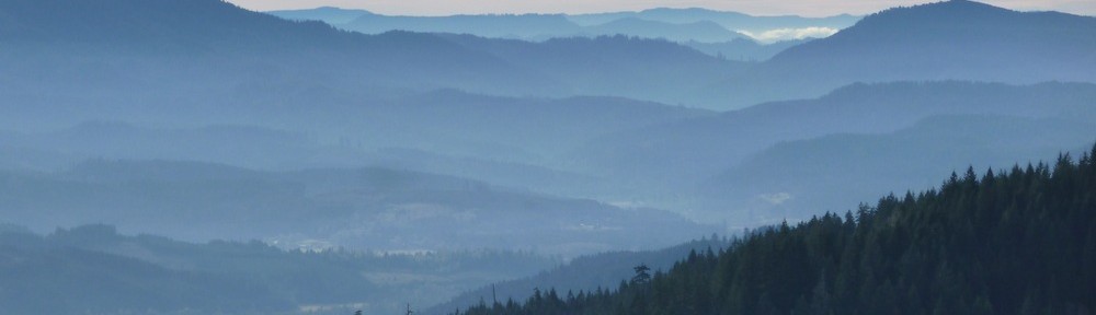
and at the reverse azimuth a full view of the loooooong profile of Prairie Mtn/Peak and the pastoral lower reaches of the NF Alsea:

TLRC had a nice quiet ride until the end, where someone was popping off with a small caliber firearm. As usual TLRC whistled as loud as he could in a vain hope to alert the gunners of his presence as he swerved into the defilade provided by the cutback. He felt pretty safe there until well behind all the action.