Grass Mountain is the big peak lying south of Mary’s Peak. At 3600′ elevation it is 500′ lower than it’s sister and the third highest peak in the central part of Oregon’s Spectacular Coast Range (higher than, in descending order Laurel Mtn, Sugarloaf Mtn and Prairie Peak, and just lower than West Ridge, a spur of Mary’s Peak). After figuring out some of the Prairie Peak labyrinth, The Logging Road Cyclist turned his attention to Grass Mtn. It took him three tries to find his way up, not to mention recourse to actual topographic maps, but it was worth the effort. The views, both from the top, and from various points along the ride up are spectacular. It is particularly worthwhile to ride up here on a dreary Corvallis day when the elevation takes one up into the sun, and gratifying to hear, upon returning, that it never showed at home, not all day long. The large meadows, from which Grass Mountain presumably gets its name, provide an exuberant, non-clearcut openness after the forest gloom below. Be careful of snow levels when heading off on this ride. TLRC has been skunked several times a couple of miles below the top by heavy snow.
The ride (gpx) (19.6mi, 4000′) is not particularly long, but it has a lot of climb and some hike-a-bike. It starts as Follet Rd., just west of Mill Cr. boat landing, which is where TLRC parks. After a steep little start, the grade moderates more to what is will be like for much of the next eight or nine miles.

Alsea Valley from Follet Rd.
This day was particularly foggy:

DeSalvo in the mists.
After the first long climb, the road drops down a bit and traverses over to the headwaters of Easter Cr. This is along the north side of the mountain which drains into the North Fork of the Alsea. This was a pretty part of the ride but there is what looks like a very heavy logging operation underway here now. The fog made it hard to determine the real extent, but this gives an idea:

Near the top, one has a choice:

The 13-8-15 road (left) goes through a locked gate and provides access to the summit road with a moderate grade. The right-hand road is steep as hell (really) and leads eventually to a landing from which the western meadow can be reached. It has the advantage of some wonderful views:

Table Mountain from the north side of Grass Mountain.

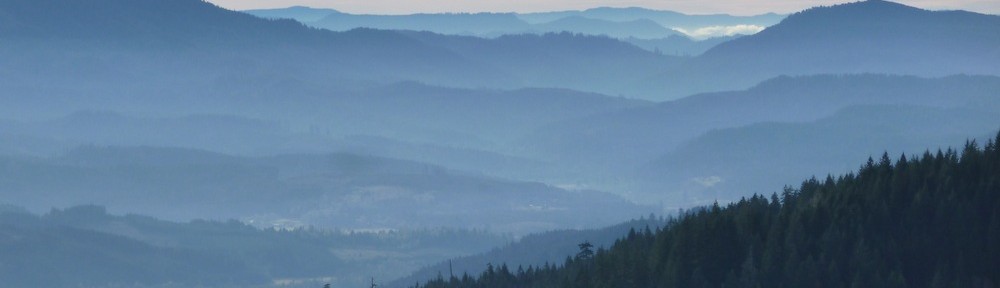
Peaks in the Laurel Mtn-Sugarloaf Mtn massif from the north side of Grass Mtn.

Mary’s Peak from the north side of Grass Mtn.
From the end of this road, at the farthest west landing, traverse through a saddle, then back to the south though the meadow (there is a faint trail at the beginning) to the beginning of the summit road (this is where the 13-8-15 rejoins).

Looking towards the start of the summit road from the meadow.
The summit road has been “decommissioned”, ie deep ditches have been dug across it, and thick yellow concrete-filled pipes stationed so as to block all but determined foot traffic. When you find this, you’ll know you’re in the right place. The next mile or so is through a spectacular stand of Douglas and Noble Fir. The road is rough and sometimes rideable, sometimes not (for TLRC, at any rate) depending upon how slimy/icy the many sticks/branches/logs are. Go slow anyway and enjoy it.

Summit forest and road.
The light in here can be fantastic. One day TLRC and a buddy were up here in a snow storm and the light through the trees was a spectacular glowing blue.
The summit meadow provides broad panoramas.

View SW(?) from Grass Mtn.

- Prairie Mountain, engulfed in cloud.

To descend, find the faint trail along the southern edge of the summit meadow. It will eventually turn into an indistinct road. You’ll hit a giant decommissioning ditch just at the edge of a landing in a huge clearcut. Follow the road out of this down down down to a gate, go left and follow the main road that will turn into Winney Rd., debouching onto Hwy 34. Go left, and back a few miles to Mill Cr. boat ramp, and you’re done.