The Logging Road Cyclist is, generally and by most accounts, an enthusiast. The enthusiasms vary, to be sure, and sometimes follow one another in rapid and bewildering succession. But (dread word), he has become a bit jaded when it comes to digging out new rides. A, je ne sais quois, comment on dit sort of ennui has settled upon him. Fortunately his riding buddy Gnat has picked up the slack and has been proposing new routes with head-spinning speed.
This one was a loop up and over the steep ridge bounding Valsetz Lake on the west. A moderate ride as they did it at 15 miles and under a couple thousand of climbing. Indeed, this ridge, comprised of a hard diorite that props up the complementary features Big Tip and Big Saddle (!) also has the prominent gap at its northern end that held the dam that made the lake they called Valsetz (after the Valley and Siletz railroad). The big surprise of this ride was all the views.
This ridge lies below all the major features that ring Valsetz Lake, but is high enough to give a clear view of the lowlands and the surrounding peaks and ridges. TLRC has visited most of them at one time or another, but their height and positions make everything seem rather distant. Big Tip-Saddle ridge, with its lower elevation, gives a closer, more uniform view of what all is going on around Valsetz. Loge seating, as it were, for a local geography and (don’t worry, TLRC will leave it out this time) geology.
Here’s an area map so the reader can get the picture.

TLRC and Gnat started just down from the old dam site, and coasted a bit to the turnoff up the ridge. Gaining the first height, they had a great view smack down the main Siletz River. This is still way up above the whitewater run, rather in the area around the mysterious Falls.

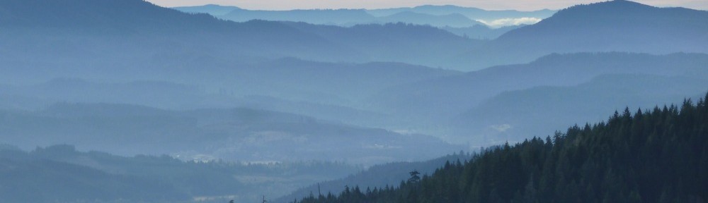
Looking south down the Siletz canyon.
As they climbed higher and higher up the west side of the ridge, the views towards Stott Mtn and Sugarloaf got better and better. Swinging around from Stott, the watershed of the N Siltetz opened up, giving a view straight into the surprisingly sharp canyon of lower Warnicke Cr. and a sideways look at Boulder Cr. over a shoulder of Sugarloaf. The dusting of snow on the high country mitigated the otherwise depressing severity of both old and very recent, massive cuts.

Sugarloaf (center). Warnicke and Boulder Crs are to the left. Valsetz dam site lies directly below Sugarloaf
After not too hard of a ride, the pair attained Big Saddle. TLRC was hot for Big Tip, and sprinted off. The correct turn was uphill, and likely that and inexcusably bad map reading caused him to lead the happily lead-astray Gnat off on a goose chase where Gnat could pose his bike before an ocean view. They also had a very good look in profile at Big Tip. Truly protuberant, that would have been a cruel endeavor to mount, and they were just as happy to deflate their expectations and head on down.

On the way down, the clarity of the relation between the Oregon Coast Range Intrusive suite and local geography, and the fact that here, it is dioritic rather than the usual gabbroic stuff (leucocratic!) broke TLRC’s usual iron will, and he held forth to poor befuddled Gnat.

TLRC explains to Gnat exactly the situation in excruciating detail
On a simpler aesthetic note, the Valley fog spilling through the Luckiamute gap between Bald and Little Grass Mtns and over Cougar Ridge was just pretty.
