Following The Logging Road Cyclist’s last foray into the Valsetz Triangle (as TLRC will henceforth refer to the region roughly defined by Valsetz-Logsden-Kings Valley, cf. Nosing Around the Siletz), TLRC’s buddy D. got all fired up again. Perhaps he thought this was all his idea (well, it was, really) and felt scooped. At any rate, rather than his usual passive self, willing to follow TLRC to the ends of the clearcuts, D. took charge and set them off to Green Mtn., plan in mind and map in hand. TLRC, long fascinated by the long ridge of Green Mtn. took little convincing.
The day was not encouraging. An inversion had trapped their Valley homes beneath a mantle of nearly-freezing fog and they hoped to escape by heading towards the coast and up towards the sky. In Philomath, D., who was driving, rather callously refused TLRC his non-fat latte at The Human Bean, and forced him to get coffee to go at the CD&J. Yuck.
Soon they reached the base of Green Mtn. Road and headed up. The ride was surprisingly pleasant along a forested ridge that soon climbed out of the fog and into brilliant sunshine.

Sun and trees, Green Mtn. Road.
Besides being pretty, the landscape was liberally sprinkled with road signs of all types, both alphabetical and decipherable numerics. An embarrassment of riches!

Prophetically, TLRC remarked to D. how nice it was to have such tight nav for a change. D. was really on the money up here, and led them up an indistinct road,

which he hoped would lead to the summit of Green, as indeed it very nearly did. As it was, they got as close as they felt necessary, and saw where to go the next time. They were dazzled by their loge seats above the mysterious Valsetz Triangle. Hounds bayed in the distance.

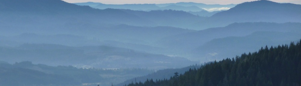
The peaks above the Valsetz Triangle (l-r): Chandler, Stott, Sugarloaf, Fanno, Laurel

Valley fog creeping over Cougar Ridge, Bald Mtn. on left..
They wandered around the summit area a bit trying to locate a road or two that were on the map, but not actually present, pondered heading down into the Triangle but demurred, citing The Fundamental Axiom, and decided to take a different road back down to the Lodsgen road.
A tributary of the main road they had come up is Fall Cr.-Hatchery Rd. It is clearly marked on the map D. had. Moreover, there is a hatchery on the Logsden road that both TLRC and D. knew. At the top of this road are TWO (2!) signs, one a post with the road name in big block letters, and a BLM sign with the same number as marked on the map, right there with the road name. Finally, every drainage on the south side of Green Mtn drains down to the target Logsden Rd., so the chance of going far astray seemed remote. Astute readers may get the sense that TLRC is indulging in a bit of ex ante whining.
With this “tight nav”, off they went, casually whizzing downhill, enjoying the well earned rest and the great day. Soon, as always, the road split into to equally-sized parts. Which to take? Both went downhill and everything at this point (they reasoned) must surely head to the Logdsen road. They went left on the most heavily used branch and once again settled into their happy downhill run. D. started to sing Powderfinger and TLRC joined in, surprised at how much fun it was to be casual, just this once, about dropping off a big ridge.
After a mile or two and hundreds of feet of descent, the road ended in a landing, as in dead-end. The singing stopped. Off came the jackets and gloves, back up they climbed. It was steep.
At the intersection, it was clear which way to go this time, and off they went, but not enjoying it quite so much. They descended into a maze of roads, some named obscurely, others not at all. Another promising (and apparently well-travelled) road led off and they took it rather than face another climb on a different branch. A mile later, another landing, another steep climb back out. Halfway up, they stopped for a rest and to gather their wits. It was 2PM. They had the light and the strength for one more failure, and then things might stop being funny. Here, D. did the unthinkable: he pulled out his iPhone and fired up the GPS. At first, TLRC was horrified at this sacrilege: GPS on a TLRC ride? How dare he? Turning away, TLRC refused to have anything to do with this, while thinking that maybe this wasn’t “his” ride, but “D.’s” ride as well and he should, well, mellow out. But then D. started muttering about how they were about a mile away from the road home, and he could see which way to go, and like Adam to the apple, or a bug to a bug zapper, TLRC was drawn in.
The “correct” version of Fall Cr.-Hatchery Rd. was closed to everything but foot traffic. Big signs said so, and they figured that “foot” pretty much meant “cross bike” in this context. Soon it was clear that they were on the right road and very close to pavement. Then the fun really stopped.

In this rare photo, TLRC is seen negotiating a deep washout filled with various sticker berries on Fall Cr.-Hatchery Rd.

In another rare action shot, TLRC emerges from the berry thickets and washout. Note “Road Closed” sign indicating that this is (was) in fact the road. There is also a stop sign facing the other way. Folks actually used to use this.
Hmmmmm. A bit embarrassing for the boys, eh? Getting lost and all. But, really, honestly, this is the first time TLRC has violated the Fundamental Axiom in a long, long time, and he won’t be doing it again soon. The lesson is this: In the Coast Range, on a bike, it doesn’t take very many small mistakes, or very long, to get into a situation one will regret. Had this happened on the other side of Green Mtn., where they had contemplated exploring on this short winter’s day, things could have become very much more unpleasant. They rejected that because it was obviously unwise, and then were lulled by clear road signs that didn’t signify reality. Ahem.
I think you are hot.