Siuslaw’s Spectacles

Since spying this route on the Forest Service map last year, and doing half of it, The Logging Road Cyclist has kept his eyes on completing it. The ride comprises two loops connected by some back and forth along the 58 road (the Backbone of the Siuslaw!).  The 58 runs atop the seaward rampart of the Coast Range and the loops drop from there down to The Ocean, and climb back up. Moderate in distance (54 miles), extravagant in climbing (nearly 10,000 ft!), the map of the ride resembles a pair of glasses as R. Crumb might have visualized them for one of his characters.

Indeed, the last panel pretty much describes how TLRC felt after the last climb to the truck.

The northern loop was already known, and since TLRC was concerned about a dicky knee (the result of pedalling his newly fitted road bike with an excess of zeal), he started centrally, in the bridge of the spectacles (the better to bail if necessary) and attacked the southern, unknown loop first.

A few miles along the 58 lead to the 1055 road that drops down the big ridge between Tenmile Cr. and the Rock Cr. Wilderness. This is not all downhill. Since this area has not recently been logged, views are restricted, but one can still get some wonderful vistas through the trees that don’t translate well into photos.

Morning light on the 1055.

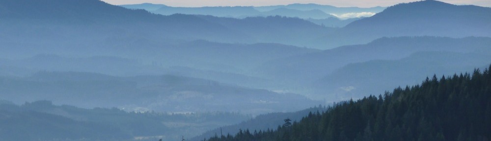
Looking across Tenmile Cr. from the 1055. Mary’s Peak in the distance.

View into Rock Cr. Wilderness from the 1055.

Eventually the road ends at

The Ocean

following which is about a mile along Hwy 101 south to the Rock Cr. Rd. This short stretch of 101 served to increase TLRC’s bewilderment about bicycle touring along it. Even granting that the drivers are alert, sober and courteous (which TLRC is adamantly not willing to do), just spending days having heavy traffic passing within touching distance at high speed seems unpleasant to him. This stretch was mercifully over quickly, and TLRC could return to his natural remote and gravelly habitat.

The run up Big Cr. is classic grinding and doesn’t get very steep until up at the top, in the last couple of miles before the loop closes. TLRC trotted up this and got back to his truck for the little picnic he had left there, replenished his water and dropped off clothing that the warm afternoon had rendered moot.

All body parts working well, TLRC took off for the second loop. Unfortunately the Desalvo developed some clunking and shifting issues that nearly caused TLRC to shed his usual unearthly calm. He was, however, determined this time to circle both lenses and he persisted.

Fortunately, this northern loop is a lot easier than the southern (although there is some substantial climbing before the bottom drops out on the last wonderful few paved miles of the 5614 into Tenmile), because after all of this grinding away uphill, poor TLRC was pretty tuckered out, and did much of the climb out of the beautiful Tenmile Cr. in an embarrassingly low gear. Fortunately, he was in his usual solitary mode, so no one was around to criticize, and it is only his unfailing honesty and personal integrity that brings this lamentable situation to light at all.

This ride is one of the best in the TLRC oeuvre and it is highly recommended. Remote, quiet roads in a beautiful setting. The strenuous nature of the ride makes it a worthwhile accomplishment.


The Fool’s Progress

After the giddy Klikitat Mtn road loop, The Logging Road Cyclist set his sights on more exotic terrain. He determined to repeat last September’s Rogue River Trail hike, to see if his feet could still take it, check out the new gear he got to improve his lot, and to enjoy the canyon in the Spring bloom. Wednesday night found him pounding down I-5 after a good-bye dinner with The Long-Suffering Girlfriend. The tasty McMinnimans burger left him sleepy by Eugene, in spite of the “Fresh Air” podcasts he had brought along for distraction, and it took a gooey chocolate chip cookie and a coke to buzz him out enough to make it to Merlin. Finding that flat-broke Josephine County (yes, home of the ophiolite) now charges $19 to sleep at the dump called Almeda Park, he backtracked to Ennis riffle and spent the night.

Getting an early start, TLRC made it 17 miles down the trail to Winkle Bar, where Zane Grey once set up shop and gathered materials for his melodramatic “Rogue River Feud”.  While getting his supper, TLRC noticed a little tick heading up his leg towards his moister regions. Wiping it off, he zipped up his tent, hoping it wasn’t too late. It was. Lying inside to get out of the rain (a VAST improvement over last year’s poncho/tarp), TLRC found and squashed three more ticks. Howling Fantods.  Ticks give TLRC the howling fantods. He shoved all of his gear to one end of the tent, checked the floor and then piece by piece went through every bit of gear. The next day he brushed more off while at Mule Creek, then getting down to the beach at Tate, and every time he left the beach, and then all the rest of the walk through the oak savanna below Clay Hill and the pastures at the end.  Part of the stress was TLRC chastising himself for being so hysterical about the ticks, but everyone he has related this story too has has the same reaction: howling fantods. This has helped.

After a pleasant week of local training rides, TLRC wanted some bigger game, and since D. was around, they decided to try the long-sought-after Laurel Mtn Massif Traverse, Falls City to the NF Siletz, back through Valsetz. Looked like 45 miles or so. Weather was so-so, 55 degrees rain (showers). After the last failure on Fanno Peak (cf. Anticipate the Obvious), TLRC was loaded for bear: rain pants, a couple of synthetic jackets, new rain jacket, neoprene overboots, food. Even D. brought a big lunch. TLRC changed in the Falls City Cemetery as usual, where he discovered he had only one contact lens. He put it in his dominant eye. D had forgotten his helmet. Off they went into a downpour which turned into a downpour with high wind, then a light snowstorm with high wind. They lowered their sights and decided to backtrack TLRC’s attempted loop around Fanno from a few weeks past. Topping out into the newly bare land comprising the edge of the highlands, the weather got bad. D had no gloves and was rapidly losing feeling in his fingers. Retreat was the obvious choice, but D’s fingers were really suffering on this long descent.

With his native generosity and inventiveness piqued by D’s plight, it occurred to TLRC that his neoprene overboots might help out, and they did.

D made it back to Falls City without excessive misery, although there was some sniveling about hands that “smelled like feet” (wait until the toe fungus gets him!).

Feeling rather smug about being so well prepared, TLRC was looking forward to snuggling back into his dry Carharts. His hubris was repaid by the discovery that sometime between changing and trying to get dressed, he had misplaced them somewhere. Not in car, Cemetery or along any road they could see, TLRC was reduced to rain pants, combat style, for the whole ride home. Worse, just a year ago he lost a pair of ($$$$$) bike shorts to the same Cemetery. Real Twilight Zone stuff.


Klickitat Road Loop

The Logging Road Cyclist’s buddy D. may wax lyrical about the Ride Around Prairie Mtn or  the Feagles Cr. Loop, proclaiming them the best  in the compendium, as is his right. And TLRC can see his point of view. TLRC, however, maintains his own counsel, and a personal favorite is this Klickitat Mtn. Road Loop. Real roadies beware: there is gravel here, maybe a total of six or seven miles overall. But given the many miles of remote single-lane pavement in a beautiful setting, why deny oneself the joy of doing it on a light, fast road eatin’ machine?

The Other Bike: an old Merlin Agilis, Mavic/King wheel set, Specialites TA Carmina triple for the hills, &c, &c.

This longish ride visits three drainages, climbing in and out of idyllic, remote Coast Range valleys divided by some steep ridges traversed by lonely paved logging roads. On Sunday,  a brilliant April day, TLRC was passed by a total of two cars in nearly six hours on the ride.

The loop starts up Lobster Valley, alternating between forest and open fields.


Preacher Cr. Rd. climbs away out of the Lobster Cr. drainage. The first mile is the steepest part, followed by a more gradual ascent and the initial section of gravel, 2-3 miles long.

View down Lobster Cr. from Preacher Cr. Rd.

A precipitous drop into the Five Rivers drainage is followed by a pleasant ride which leads to the second substantial climb up to the 32 Rd.

Upper Fiver Rivers Rd.

Beyond the intersection of the 32 and 3250, a pleasant rolling descent is followed by the steep drop into Indian Cr. (some gravel here),

Indian Cr. Rd.

and, after some pleasant miles along this major road, the turn onto Thomson Cr., where this bucolic aspect

Looking up Thompson Cr.

belies the constant wariness maintained by its denizens, doubtless concerned about hordes of KLCC listeners descending with health insurance policies that must be bought, or else:

Getting “out of range”, the biggest climb up to the flank of Saddle Mtn (with gravel on the initial climb up Thompson Cr.) leads to Rd. 58, “The Backbone of the Siuslaw”, along which one rolls through a few miles of rock, back to pavement and the final descent back to Five Rivers and six miles of fast pavement to the end.

This is 65 miles of pretty much nowheresville, so be prepared to take care of yourself. Bring lots of food, water, tools, and tire stuff, because there sure isn’t any out there. It’s easy to start daydreaming along, given the lack of cars. Remember, the few drivers feel that way too, and you may (as TLRC has done) come around a corner and find yourself face to face with a driver just as  surprised as you. Or a bear, or mama big cat for that matter. But for an adventurous and beautiful ride, it’s hard to beat this.


TLRC Doings…

Since the last post, quite a while ago, The Logging Road Cyclist has been leading a quiet life. After that freeze out, he bought a Nano pullover so as to stay warmer, sent his Torrentshell jacket back to the manufacturer in hopes that they would replace it with one that doesn’t leak, so as to stay drier, and bought a rather tacky, but hopefully useful compass so as to stay more oriented.

Stem Captain

Whether or not any of this helps, well, as Donald Rumsfeld says: “Time will tell.”

TLRC has also been doing some riding, but not much that is post-worthy, mostly just the usual local training stuff. He did get out on the last sunny weekend to do the first Ride Around Prairie Mountain of the year. This is, according to D. the best of all the TLRC rides. A discussion about that led TLRC back to this gem, where he got a few interesting pics, like this one of the almost-100-ft-long-picinic-table-made-from-one-slab-of-Doug-fir in the pretty-skanky-Hubert-McBee-Park:

All this neo-Cold War feeling over the Crimea made TLRC feel lucky that Lane County is a real refuge for us all in case of need:

And there was this gentle reminder that, no  matter how remote the road, there may be a driver who can make for an uncomfortable situation:

A pretty fresh wreck above Lobster Cr.

As usual the ride was good. Even the blowdown of the last few miles wasn’t too bad, just inconvenient. Certainly worth the effort.

Yesterday, being a good Dad, he took his girls out for a hike over Cardwell Hill Road. Just over the top, Devil Puppy came bounding down onto the road, missed her landing and scraped along on the side of her face for a while before bounding away. Ten or fifteen minutes later, TLRC noticed that what looked like a coating of mud over her entire front was actually fresh, bright blood, apparently coming from a through-and-through bite wound in her tongue. There were no other visible bleeding holes and the copious amount dripping from her tongue seemed fully capable of doing the job of covering her. Back at The Forest Estate, after baths, she started bleeding again, and TLRC found a puncture  in her neck as well, so off to the 24-hour ($92 to walk in the door) emergency vet, where the final tally was:

Broken tooth, big gash in lip, two puncture wounds in neck, lacerated tongue: $850 with Elizabethan collar.

Dad loves me! He says I’m worth more than the red Chris King ISO hub set he was going to buy this month!

Anticipate the Obvious

One overcast day in the early 1980’s, The Logging Road Cyclist and his climbing partner Joe Erg found themselves on a ledge high up on one of the granite slabs that the Squamish climbing area is noted for. Robin Barley had told them this was a good route to do (it was an old one of his), but up to this ledge, it had consisted of a difficult, damp and scary dihedral, poorly protected and run-out. They now were at what appeared to be the crux, another damp stretch of granite leading up to a blank-looking overhang. Whatever lay beyond was not visible, and the overhang itself was strongly backlit, and hard to discern. The only protection in sight was a single quarter-inch bolt. The bolts at Squamish deserve special mention. Since Squamish lies adjacent to an arm of sea, and has a very wet climate, climbing bolts rust. Some of the older bolts there had corroded to the point where they looked like nails pulled from the hull of a sunken Tudor warship, as did this one, and indeed all the previous ones on the route.

To TLRC, the results of continuing were pretty clear. If the route got any harder, damper or scarier, they weren’t  going to get much farther, and it looked like all three of those things were about to happen simultaneously. There was always a chance that boldness would prevail and they would make it on up, but if the recent past was any guide, one of them (and it was TLRC’s lead) was going to wind up extricating himself from an unenviable situation involving down climbing the roof with only that bad bolt  below it. Why not, TLRC pointed out to Joe Erg, “anticipate the obvious”, and rappel from this comfortable ledge rather than come down god knows how from above that overhang, and then go and find a more profitable use for the remainder of the day? They did, and when Barley was told, he had an (inordinately, in TLRC’s view) explosive bout of laughter. Barley knew full and well the condition of the route, and had sandbagged them. (Until writing this, TLRC had always held a grudge against Barley for this climb, but in retrospect, it wasn’t too long after TLRC had taken Barley down Tumwater Canyon, where he (Barley) had gotten pinned in a drop with his boat crushed on him and TLRC had to haul him out. All this happened as Barley’s distraught wife looked on. TLRC always just figured it was Barley’s fault and didn’t think much more about it, but perhaps Barley had a different take.)

TLRC, a humble man, eschews self-quotation as a general rule of personal conduct. On the other hand, “If the epithet fits, spout it!”, seems an equally good rule, so there you have it. Since coining the pithy phrase, TLRC has often found himself comforted by using it as a mantra in deteriorating conditions, usually brought about by self-sandbagging.

Take Saturday, for example. It was supposed to rain (well it was definitely going to rain), but the temperatures were to be in the 50’s. To TLRC this seemed pretty warm, and he had fixed in his mind a ride not unlike one on the wet side of Oahu, wherein he might get soaked, but not miserable. Changing in the Falls City cemetery, he felt an unexpected chill, and wisely selected the heavier of the pair of tights he had brought.

He set off on the Valsetz Road, the kind of ride one does when his spirits are unnaturally buoyant, and he feels the need for some stabilization. Eight miles and 2500 feet up a heavily travelled, heavily logged road usually brings one back to earth.

Outstanding, fascinating scenery on the Valsetz Rd.

TLRC had a new goal: traverse from the Valsetz Road along Fanno Ridge to the peak, then back through known ground to Falls City. Seemed simple enough, given that Fanno Ridge, the northern boundary of the Valsetz Triangle, is one of the bigger features around.

At the Fanno junction, TLRC was surprised to find he was cold after all that climbing. Facing the Hobson’s Choice of being wet by the rain with no jacket, or being wet by sweat with one, he did both and was faced with starting out on the exploratory phase of the ride “pre-chilled” as it were. At some point, TLRC was going to make a big descent, and it seemed the wisest course to keep his extra layer in reserve for that, or for some unexpected unpleasantness. He compromised by putting on his gloves and set out for Fanno.

By this time, clouds and heavy mists were wafting up from the Triangle, and visibility varied from a few hundred feet to a few hundred yards. The road seemed “main” enough, fresh rock and new mileage signage, but no interpretable numbers (i.e. BLM ones to match his map). TLRC found the first major intersection, but the left-hand choice didn’t seem “main” enough so he stayed on the “main” road, looking for the next obvious, right-angled intersection. The next one didn’t look at all like it would do, so TLRC stayed on the “main” road, and found himself dropping rapidly into god-knew-where, all sense of direction evaporated and getting more chilled to boot. As the “main” road continued to descend and split into smaller and less “main-looking” spurs, it was becoming pretty “obvious” that TLRC was not going to make the ride, and the sooner he “anticipated” this and got out of the steady rain, the warmer he would be in the end.

He trudged back up to the Valsetz Road, put his extra layer on next to his skin, and his wet layer on over that, buttoned up and swept down to Falls City, by which point he was pretty cold. Even the full heater in the truck didn’t help much, and he found himself shivering over his Eugene Weekly and sub sandwich back in town. Even a dessert brownie didn’t help, and it was only after half an hour under The Long Suffering Girlfriend’s bathroom heater that TLRC felt his usual toasty self again.


Off To See The Wizard

The Logging Road Cyclist was in a somber mood, and dearly needed a good ride to set up his spirits. Saturday was absorbed by attending a memorial service for another passed kayaker. This one, B, hailed from the earliest days of TLRC’s paddling career. Along with his older brother C, B was a fixture in the early ’70’s whitewater scene in the Bay Area, when TLRC barged into it at eighteen years old. B, C and TLRC were about the same age, but the former were both already very accomplished paddlers. They provided inspiration for the flailing TLRC; in return he provided them with much amusement as he variously missed rolls, swam, broke boats, bent paddles, etc etc, the usual antics of a hyper-enthusiastic, under-skilled novice paddler. B went on to Olympic-level flat water racing and a stellar academic career, C to slalom and ever more hair-raising whitewater on much of which TLRC joined him along with fellow teenagers R and Heathcote. While TLRC only knew B during the ’70’s and drifted away later, B  formed a part of the pattern in the fabric of TLRC’s life at an important time: for TLRC whitewater was formative and sustaining for his entire adult life, and B was there at the start of it.

Aging is tough. As Philip Caputo put it in one of his novels, 50 is the age when a man’s friends start to die. At nearly 60, TLRC finds this true, and it is especially unnerving when the friends are younger and arguably as fit or fitter than he. B was 57, still an athlete, a student of heart physiology: he did all the right things. Heathcote, the friend of TLRC’s life, went 5 years ago in his early 50’s from a fast, hot cancer that was never figured out. Thus TLRC, R and C are left, and at the goodbyes to their friends and brothers they find themselves together in the midst of grief, wondering why, sharing the past, sheltering with each other in the now.

Thus the need to get out. Coupled with the flail along the North Siletz before the big snow and rain shut down the backcountry rides for a few weeks, TLRC wanted to actually accomplish something.

Fortunately the steadfast D was available. He too needed to get out. A lobbyist for fish, D had been doing a lot of fish-saving lately, and while much of what D does mystifies TLRC, it is apparently fairly sedentary.  D is a good companion in times like these. He empathizes as much as is needed, but not more, and refuses, in an amazingly diplomatic way, to allow TLRC to wander down into the dark cul-de-sacs of the TLRC mind. In short, he gives TLRC exactly what it is that TLRC needs at these particular times. Plus, D infused the day with an undeniable spiritual energy. While TLRC was down in Eugene grieving, D was up on the Necanium catching his first wild steelhead on spey gear. The fullest meaning of this may escape TLRC and other civilians, but since D carried what looked suspiciously like a halo all day, TLRC figured it was a Siginificant Life Event, as it were. At any rate, it cheered things up.

Check this out:

The red line is the first 13 or so miles of the Luckiamute River, which flows from high up on Bald Mountain, down through Kings Valley and Pedee to the Willamette, 50 or so river miles away. TLRC had first sort of noticed this a few years back, but with all the recent riding activity in the Valsetz Triangle, he went back to his maps to see if it was really true that the Luckiamute actually spiraled down off Bald Mountain like this. It is impossible that this is a unique sort of watershed, but TLRC can’t recall seeing one himself. It brought to mind certain other spirals:

Unique or not, it certainly beckoned, both to D and TLRC, and they were drawn to it, that and the fact that they had both stumbled around on the east side of Bald Mountain a year or so ago and were looking for another opportunity to go back and connect some dots, fill in some blanks.

So Sunday’s project was fixed. From the Hoskins-Valsetz road, up the spiral along the upper Luckiamute, around the east side of Bald to the Summit, back around the west side and then connect north to the Valsetz Road. A swoop down the South Siletz (site of recent spawning studies by D and dedicated Bluebacks) to Valsetz and then back over to the Luckiamute. This ride would allow a lot of connections to be made between the various watersheds recently explored by our team.

The upper Luckiamute is a pretty stream, and maybe kayakable, just.

Luckiamute at the second bridge. Note handmade bicycle in British Racing Green.

Upper Luckiamute

View W down the Luckiamute. Fanno Peak in the distance.

Bald Mtn from the North, looking across the Luckiamute.


Pond at the origin of the spiral.

Once past the headwaters, there are spectacular views from the east around to the west, like this one into the Valsetz Triangle.

Valsetz Triangle from Bald Mtn.

The largest clearcut in the distance on the right side of the photo lies above Valsetz Lake and the exit of the SF Siletz. The indistinct low ridge in front of it is the Siletz-Luckiamute divide. Note the hummocky, dissected terrain that forms the upper part of the Luckiamute watershed. A point of interest: As if the Siletz basin hasn’t been insulted enough already, there are plans afoot to rebuild the Valsetz dam to for water storage purposes. Apparently Polk County intends to sell water to thirsty coastal towns and use some for itself. Avid Siletz steelheaders are not pleased….

Finally, from the summit of Bald Mtn are spectacular views of the Willamette Valley and Cascades that the cheap camera and poor skills of TLRC cannot do justice to:

View E from summit of Bald Mtn.

The route around the west side of Bald is straightforward, as is the connection north to the Valsetz Road, which is a fun slide down to the lake. An easy climb leads back to the start of the ride.

This is a moderate (26 miles, 3600′) ride that takes in a lot of country, has some beautiful stretches of forest (on BLM lands), great views and connects a lot of the watershed topology of the area. Highly recommended. The ride is here: ignore the last few miles with sustained speeds in excess of 20mph. The ever-helpful D loaded up TLRC’s bike before the GPS got turned off.


Big Reorganization!!!!

The Logging Road Cyclist was  initially conceived as a simple catalog of bicycle routes  through the Oregon back-of-beyond. The original structure of the site reflected this: organized geographically, rides were listed by regions set down by TLRC himself. At the time, the notion of a serious blog had not surfaced. As time has passed, however, TLRC finds himself more drawn to the blog format (god help the world, a pontificator with an IP) , wherein the latest adventure is memorialized in a post. More energy is going into blogging at this point than into cataloging, mainly because most of the “established” routes have been cataloged, and also because most recent adventures have not risen to the level of catalogable rides. Not that the rides aren’t interesting…

Of late, TLRC has felt burdened by the old format, that his creativity is being stifled by an outmoded structure, albeit one of his own devising. Thus, he is ushering in the new: henceforth, rides will be blogged about, and in the “Rides” section of the site, still organized geographically, links to the blog entries will be provided. Hopefully this will allow TLRC maximum freedom to pontificate, while retaining a measure of the geo-spatial organization that has undoubtedly proven so useful to the scores of adventure cyclists that TLRC is sure have come to rely on the site as a source for inspiration and guidance.

The Big Reorganization will be an ongoing, organic process. TLRC begs patrons for their patience.


North Fork Siletz

The Logging Road Cyclist was feeling frisky last Saturday, so he took off for somewhere new, namely to attempt Stott Mountain. This was an old idea of D’s, but since he wasn’t around, TLRC decided to go off and have a look for himself.

Stott is high by Coast Range standards at just over 3000 feet. It looms over the NF Siletz across the way from Sugarloaf Mtn. and the chasm between the two peaks is something to behold. Also beholdable, as it were, are the truly massive clear cuts that have been visited on this whole drainage. In spite of that, the NF Siletz is a beautiful stream that hides away in the peaceful remnants of its valley.

Not all is gone. At the head of the North Fork is a little set-aside of old growth, the Valley of the Giants, which the BLM holds as an artifact of what once was the nature of this region.

The road net around Stott seemed, on the maps and Google Earth, to be pretty complex. TLRC’s  plan was to head up the NF and then find his way to the summit by one of a couple of roads that was clearly marked on all his sources. Descent down the south side seemed pretty straightforward, given that there are some pretty distinctive loops and junctions that TLRC thought should be pretty obvious.

Driving in from Hoskins is a long 40 miles, a 20/20 split of pavement and gravel. Crossing over the Luckiamute-Siletz divide, TLRC saw that the high peaks had snow, and heard a huge engine roaring down towards Valsetz, perhaps a big helicopter. Just to be on the safe side, he wasted another 45 minutes going up Gravel Cr. to check that his planned descent road actually existed, and it seemed to. Returning to the base of the NF road, he set off upriver.

TLRC had been here before. Once, with #2 wife, he had run the river in a tandem open boat, and then later with kayaks he returned with his buddy Dan Coyle (maker of fine custom wooden helmets/objets d’art). That trip turned into a minor epic. Dan forgot the front wheel of the shuttle bike, so once the run was done, they walked the shuttle, up to Valley of the Giants. On the way back TLRC’s truck blew a tire on the steepest part of the road, so they changed the tire in the precarious dark (no flashlight). Mobile again, they couldn’t find where they had stashed their boats (no flashlight). Navigating by the sound of side creeks, they found them after what seemed like a long time. They got lost on the snowy road net on their way home, and after another long time of almost complete bewilderment, stumbled into Falls City, a long way from the target, Hoskins, but at least somewhere they could get home from. TLRC bought one of those big cop flashlights the next day, along with a new tire.

The ride up the river is quite pretty, and as it was yet another of the fine, very cold January days, TLRC enjoyed himself.

Ledge, NF Siletz.

Boulder Cr.

After the steep climb above the bridge, one comes to the Valley:

Valley of the Giants kiosk.

Beyond there, it seemed simple enough: follow the road along the river for a couple of miles on the clearly designated road:

Dead End #1.

which actually runs into this bridge not far from VOG. Being loath to cross this decayed log bridge while alone and spend the next hour bushwhacking only to have to cross it again, TLRC opted for the other clearly designated road, which, after a couple of steep and rocky miles ended thusly:

Dead end #2.

If nothing, else, these are prime examples of The Fundamental Axiom: had TLRC foolishly gone up what appeared to be the simple south side roads, hoping to have dropped down these, he would have been in a fine kettle of fish.

On the way back downriver, TLRC stopped to admire and photograph this scene. A new clearcut into the small, dense, second- (third?) growth that predominates here reveals what once was. As if emerging from a receding sea, the forest floor has been exposed, revealing the huge, dispersed stumps of the original forest that, like Valley of the Giants, ruled before man.

Atlantis Rises.

Table Mountain Summited!

The Logging Road Cyclist can state, without fear of protesting too much, that he has not OCD. Not to say that TLRC doesn’t run a tight ship. Far from it! No clattering derailleurs, rubbing fenders or spectrally creaking frames for him; furthermore, summits once tried must be reached, loops explored must be closed.

Lately, the big radio tower atop Table Mountain has been sneering at TLRC. Visible from most anywhere, it is the symbol of Summit for that peak. TLRC has been close a couple of times. On the first trip, he made the grueling climb up from Drift Cr., only to wander gormlessly around the quarries, lacking any sense of where the tower might be. About a year ago, this time armed with a route to the tower gleaned from the Google Earth, he didn’t get that far, but, citing feebleness and a late start only got to within a half mile or so of the quarries (cf. Table Mtn).

Thus it was that today, in order to enjoy the unseasonably balmy weather and also to take a break from the Valstz Triangle salt mine, TLRC aimed himself once again at the tower atop Table Mtn.

It was a truly beautiful day. No tights. The air went from chilly to spring-like warmth and back again. Ice in the shadows, summertime out of them. Big doings since TLRC’s last trip here. A new logging setup pulling out what was left of the trees at the top of Grant Cr. A lot of new, heavy (4″-minus) rock all around, mostly on new landings, indicating that  Savage Cr. is next.

In good order TLRC got to the base of the big climb, had a rest and a snack and hauled himself up. No stops, in spite of the gorgeous views up the Coast Range, over to the Cascades and down to the surf at Newport. A little side trip to view the quarries and pick up a sample of the nepheline syenite (a blue-tinged, whitish rock used on all the roads around there), and then a jaunt up the obscure road to the summit.

The tower is really big. It doesn’t stand out so much from a distance for nothing:

Table Mtn. Tower.

The views from here are, well, arboreal, and while it’s a nice forest, if you want a real view, stop lower down.

Looking NW from base of tower, Table Mtn. Summit.

Doing this ride again made TLRC realize how much he enjoys it. It’s a grind at 27 miles and nearly 6000′ of climbing, and there are a lot of clear cuts that would make great posters for environmentalists making a point about what not to do. On the other hand, the views, great descents and climbs, feeling of remoteness and pockets of surprising beauty make this a wonderful ride.


TLRC Apparel!

Here at The Logging Road Cyclist, we value a strong sense of community. Further to that end, we are at the design stage of our own line of TLRC Apparel. For a first run, we are considering a hard-rock themed line of black, 100% cotton American-made Tees and hoodies, with front art thus:

and on the back:

Order yours today, and become part of the TLRC Family!

(TLRC acknowledges D., Marketing Genius, for this idea.)